Panama declared a nationwide state of emergency after two powerful earthquakes, measured at magnitudes 7.7 and 6.6, struck hours apart and damaged hundreds of buildings.
Story Highlights
- Two major quakes hit Panama the same afternoon, with strong shaking across central provinces.
- The government declared a state of emergency to coordinate relief and evacuations.
- News reports counted at least 27 minor injuries and damage to homes, roads, and public buildings.
- United States Geological Survey data logged intensities up to “violent” near the epicenter.
What happened and when
United States Geological Survey (USGS) records show a magnitude 7.7 earthquake struck near Pitaloza Arriba at 17:56:06 Coordinated Universal Time on October 9, 2026. Hours later, a magnitude 6.6 quake hit near Río Grande at 20:25:39 Coordinated Universal Time. The agency mapped maximum shaking intensities of IX for the first event and VIII for the second, which are levels that can cause severe damage in vulnerable structures.
The timing placed the first quake at about 12:56 p.m. local time and the second near 3:25 p.m. local time, affecting many people at work, school, and on the road. Reports from the scene described toppled buildings and people fleeing into open areas as aftershocks continued into the evening. The United States Geological Survey Earthquake Hazards Program page for the 6.6 event lists population exposure and likely impacts in nearby communities.
Damage reports and emergency declaration
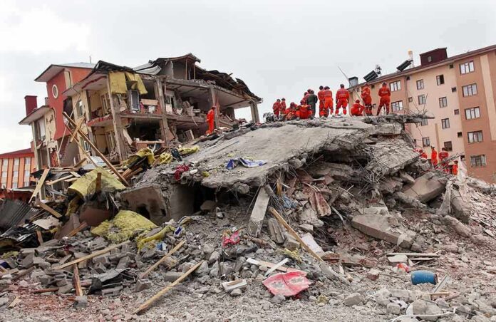
The Associated Press and BBC Mundo reported at least 27 minor injuries and damage to hundreds of buildings across the affected area, including homes, businesses, roads, and government offices. Photos and video showed cracked facades, collapsed walls, and debris in streets near the epicenter. Authorities and local crews began rapid checks of schools, clinics, and bridges to spot dangerous failures and to guide evacuations where needed.
Presidential Minister Juan Carlos Orillac announced a state of emergency at a news conference in Panama City on Saturday, October 10, 2026, following the quakes and continuing aftershocks. The government framed the move as a way to coordinate relief, speed purchasing, and direct resources to hit towns. Officials also urged people to keep phone lines open for emergencies and to follow guidance from civil protection teams on aftershock risks and building reentry.
How strong shaking translates into real-world risk
The USGS intensity scale of IX, labeled “violent,” can throw heavy furniture, shift buildings off foundations, and break underground lines. Intensity VIII, or “severe,” can cause partial collapses in weaker structures and major cracks in better ones. These intensity levels match reports of toppled buildings and injuries near the epicenter. They also explain why authorities warned about reentering damaged homes and why engineers must check columns, beams, and shear walls before people go back inside.
Earthquakes of this size often have many aftershocks over days or weeks. That pattern keeps stress on already damaged structures and can trigger landslides or new road failures. Local teams need clear maps of damage, fuel for heavy equipment, and safe shelters with water and sanitation. In rural zones, inspections of wells and small bridges are key to restoring daily life and farm-to-market routes after the first response phase.
Why this matters beyond Panama
Pipelines, power lines, roads, and ports form regional trade links. Even short-term shutdowns in a country like Panama can ripple into supply chains for food, fuel, and consumer goods. United States importers and shippers will watch for any transport slowdowns from damaged routes or inspection backlogs. The United States Geological Survey notes that quick, accurate hazard data can help responders set priorities and reduce these knock-on costs by steering aid to the highest-risk areas first.
For Americans, this is also a reminder about basic readiness at home. Many families live near faults in California, Alaska, the Pacific Northwest, and parts of the Central and Eastern United States. Simple steps—drop, cover, and hold on; strap water heaters; secure tall furniture; and store water and medicines—can save lives. Governments manage big disasters, but neighbors, churches, and local groups often fill crucial gaps in the first 72 hours before full aid arrives.
Information gaps and next steps
Officials and news outlets gave clear facts on the quake sizes, times, and broad impacts. Some details remain pending, such as a full list of road closures, the count of red-tagged buildings, and the legal text and scope of the emergency decree. As engineering teams finish inspections and civil protection agencies add field data, injury and damage totals may change. That is normal in disaster reporting and reflects better information, not confusion.
Sources:
youtube.com, ajc.com, globalnation.inquirer.net, usgs.gov, bbc.com, english.news.cn